HOT HOT HOT CATEGORY 5 STORM IS BREAKING EVERY RECORD
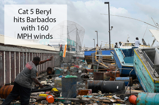
After having leveled 90% of the buildings on Carriacou, Grenada, Cat 5 Hurricane Beryl has already broken lots of records as it barrels toward Jamaica. The rapid intensification of this storm is unprecedented for this time of year (and for most any time of year), a condition made possible by Atlantic surface temperatures that are historically high. Rapid Intensification (RI) is defined as an increase of 35 MPH or more in a storm’s wind speed over 24 hours. Beryl’s wind speed more than doubled to 160 MPH from Monday to Tuesday.
The year 2023 was the warmest globally on land, sea and air. According to Copernicus’ ERA5 data records from June, 2024 is already hotter, with global sea surface temperatures across most of the world’s seas at unprecedented levels even as the El Niño cycle slackens.
The current temperatures are typical of September, not early July. On average, the first hurricane of the Atlantic season tends to form during early to mid-August. The first Category 3 generally doesn’t usually occur until Sept. 1, records show. Beryl hit Cat 5 in early July.
Average daily sea surface temperature for the month of May hit a new all-time high of 69.67 F a monthly new record for the 14th month in a row. In a nutshell, the temperatures we are now seeing are decades ahead of what climate models predicted.
DEEPER LAYERS OF HOT WATER INHIBIT SELF MODERATION
It’s fairly easy to grasp how extreme heat and water vapor levels can contribute to radical spikes in a storm’s intensity. But there is another factor contributing to Rapid Intensification that is less intuitive: the DEPTH of the upper layer of warm ocean water. In the past, when a storm passed over very warm water it fed off of the energy stored in the water, but also churned up that top layer to allow cooler water to rise from below.
Up until a few years ago, the normal scenario was that mixing of the cooler layers lowered the over all temps at the surface, reducing the energy available to the storm and therefore the intensity. In a sense, there was some self-regulation built in to the systems. However, with warmer surface layers now extending deeper, the upper layers stay warmer, the system energy stays higher and storms continue to power up.
The planet’s seas have been absorbing heat and CO2 for decades, and we are now beginning to pay the price. Storms like Maria, Otis, Beryl and those that will follow this season are a preview of what is coming.