As of July 13th, the global ocean sea-surface temperature has set a daily record for the 42nd day in a row. Landslide buries residents in southwest China’s Chongqing city | Northeastern Brazil is looking at 102°F; Spain reports 102°F and 104°F in France ; French exceptionally intense drought threatens ag three rugby players in Malaysia died of heat stroke; Egg-sized hailstones wrecked vehicles and caused serious injury in China; Four inches of rain in an hour submerged large parts of Comilla City in Bangladesh.
Apocalyptic toxic clouds envelop large swaths of North America
Billings, Montana hit’s 111°F.
South Central TX hit by more record floods while awaiting aid for last year’s catastrophic floods

Watch Thunder Key, an original music video
catastrophic floods and landslides

Shanghai climate whiplash: heat | floods | heat
Record rains followed record heat (104°F)
as Shanghai roads flooded after thunderstorms brought torrential rain to the city on mid-July. More than 8 in. of rain of rain fell within five hours in Yangpu district, inundating underground supermarkets and malls. Local weather authorities expect heavy rain to continue in the coming days.
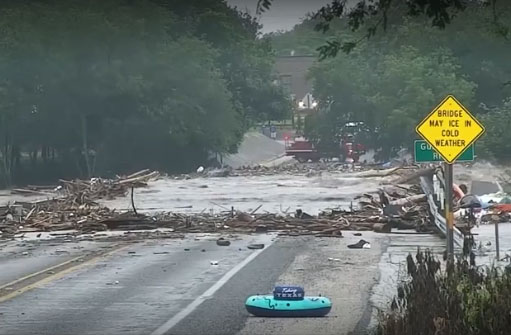
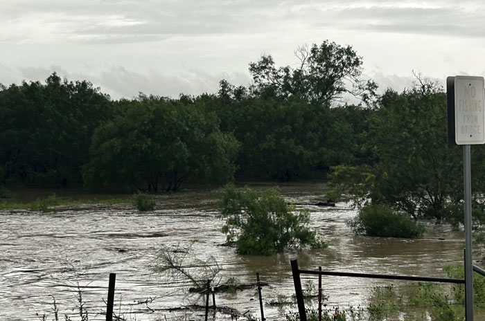
Kerr County & Central TX hammered by killer floods
Two people died in fast moving flash floods in the same area of Texas still recovering from the deaths of two dozen campers last year. The floods on the Guadalupe River forced hundreds of rescues in western Kerr County,. Rescuers saved more than 200 people, including stranded drivers and people trapped in homes.. More rain is expected.
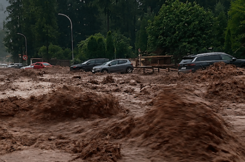
Cars swept away in Romanian mountain floods
A powerful flash flood swept through the mountain town of Bușteni July 19, carrying cars, rocks, and debris through the streets and blocking traffic on the busy DN1 national road. Emergency crews rescued several people trapped by the floodwaters, while dozens of homes were inundated.

The winds
180 MPH Super Typhoon Bavi record breaking wrecking ball
The ninth typhoon of the year formed over the northwestern Pacific Ocean on July 2. It moved northwestward and intensified rapidly, reaching super typhoon status just 42 hours after forming after four consecutive upgrades in intensity. The storm was about 1,000 in radius at its peak.
Bavi reached peak intensity with maximum sustained winds of 180 on July 4 and maintained super typhoon strength for about 135 hours, a rarity. The extreme winds extended about 100 mi from the center, twice as much as expected.
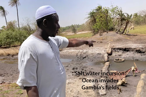
Ocean intrudes on Gambia’s fields as sea levels rise quickly
A combination of climate change and human activities is pushing ocean waters further into the coastal African nation of Gambia, threatening ecosystems, aquifers and agriculture.
“We call it a ‘wet desert.’”
The incursion is manifesting along coastlines and in river deltas, where rising sea levels move saline water into fields and villages. The ocean water makes its way underground, changing the chemistry of the soil Droughts increase salinity too, since there is less rainfall to dilute or flush the salt out. Soil and aquifer salinity levels are increasing as coastal cities pump more fresh water out of the ground, sucking ocean water in. Both phenomena are expected to worsen with global warming.
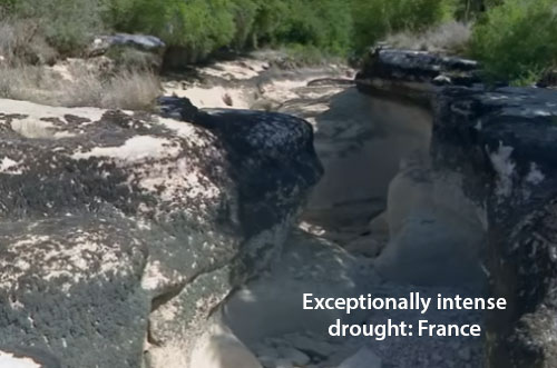
French exceptionally intense drought threatens ag
Large parts of France are facing water restrictions as the country grapples with a, intense, prolonged and early drought. France has been experiencing its third heatwave in as many months, accompanied by fierce wildfires further fueled by dry conditions. Many key rivers and streams are historically low with flow rates falling rapidly across the country since June and a quarter of small water channels running dry.
“Climate change is causing “a profound disruption to the water cycle”

Landslides kills dozens in Chongquing, China
An unknown number of people were buried after a landslide struck a county in the southwestern Chinese city of Chongqing on Friday, causing multiple residential buildings downhill to collapse, according to state media.
Aerial footage from CCTV showed rock and debris falling on a cluster of riverside residential buildings, while people could be seen fleeing with a thick plume of dust billowing behind them.
.
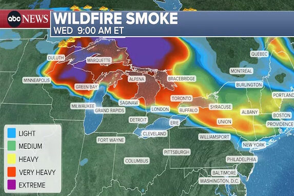
Apocalyptic skies in USA as Canada burns again
More than 830 wildfires were burning mid July in Canada, along with more than a dozen in northern Minnesota. The conflagration is growing (July 15) with no containment. , near the border, growing with little or no containment and forcing mandatory evacuations. Massive quantities of poison smoke are blowing into the Midwest and Northeast. Some of the largest wildfires are burning in heavy forests , spewing even more smoke than previous fires. It escapes many that smoke from these fires is very toxic, with effects that many manifest many years later.
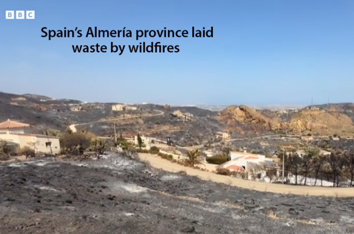
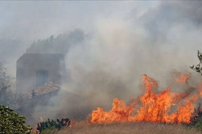
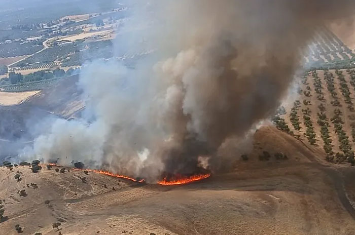
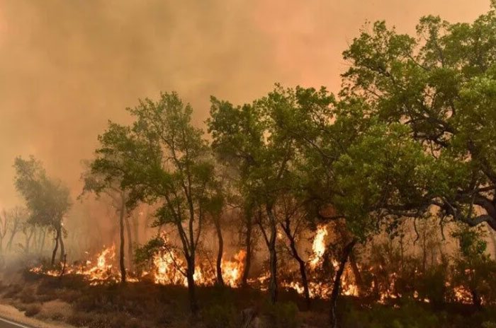
12 dead in horrendous Spanish wildfires
Described by a BBS reporters as “a sea of black,” the village of Bédar, in southern Spain’s Almería province has been virtually razed to the ground by a massive wildfire The blaze spread rapidly through the region in early July. Hundreds of firefighters have fought the fires, which have claimed the lives of 12 people. Wildfires have burned through 16,300 acres) in the province. France, Portugal and Spain. have seen devastation early this summer by a sustained heatwave with temperatures of around 104°F (40C) .
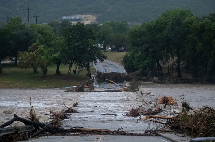
Central Texas hammered by another killer flood
Two people have died in fast moving flash floods in the same area of Texas still recovering from the deaths of two dozen campers last year. The floods have killed two people and forced hundreds of rescues in Uvalde, Edwards and western Kerr County, much of which is awaiting help from the Feds and Texas. Rescuers saved more than 200 people, including stranded drivers and people trapped in homes.. The hardest-hit areas are expecting more rain and are not out of danger yet. More
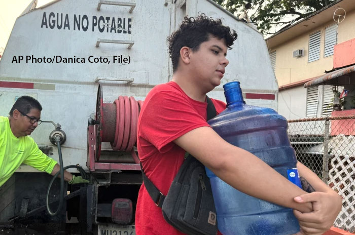
Puerto Rico drought continues as water rationing begins
Puerto Rico announced water rationing measures on Thursday as a drought grips the U.S. territory, worsening chronic water shortages that have forced the governor to declare a state of emergency. Thousands of people in the island’s northeast region now face 48-hour rationing periods. The rationing program will affect several communities in the cities of Canovanas and Rio Grande as temperatures continue to rise.

Russia’s Sochi region again surprised by landslides
On July 15, heavy rains caused flooding in the southern Russian resort city of Sochi disrupting traffic and damaging vehicles. Residents of the Ministerskie Ozera apartment complex woke up to a nightmare after torrential overnight rain triggered severe flash flooding. Streets were covered with mud and debris after torrential rain and thunderstorms caused the Bzugu River to overflow its banks.
Fire and Rain: Sicily’s climate whiplash
Sicily goes from fire to hail in a matter of hours. After days of African heat, scorching temperatures, and muggy weather, the island is dealing with wildfires in several areas and the first violent thunderstorms heralding the change in weather.
200 evacuated in Andalusia: 113°F record
Spain has just emerged from a record-breaking heatwave that left hundreds dead and pushed temperatures beyond 113°F. Following a record dry spell in May, topsoil has been stripped of moisture, eliminating the land’s natural ability to cool itself – and creating near-ideal conditions for fires to ignite and spread. Authorities have warned of a high risk of wildfires amid a worsening drought, with the accumulated heat expected to persist into early July.
Morocco issues red alert as temps hit 116°F
The fire risk warning comes alongside a weather alert issued by the General Directorate of Meteorology regarding a heat wave from Tuesday through Thursday, with temperatures reaching up to 46 °C (116 °F) in some regions of the country

Killer European heat dome to return in July
Parts of central, eastern and southern Europe are sweltering this week with Budapest forecast to exceed 104°F today. Temperatures are forecast to soar across much of western Europe early next week, after a record-breaking heatwave caused hundreds of deaths. The late June 2026 heat dome produced record temperatures in Paris, with four nuclear reactors shut down because the cores could not be cooled.

Dangerous heat wave grips USA as wildfires trigger evacuations
Evacuations have been initiated in several states due to wildfires as a prolonged, dangerous heat wave intensifies across the eastern half of United States the week of June 30. As part of the wave, some all-time high temperature records could be set later this week, NOAA’s Weather Prediction Center said. In all, some 90 million Americans live where an extreme heat watch or extreme heat warning is in effect.

Global ocean sets new all time heat record in June 2026
European Union monitors say the first half of 2026 was marked by sustained and exceptional ocean warmth and forecast more to come.
“Current conditions could indicate the beginning of a new phase, leading, once more, to uncharted territory.”
Warmer oceans increase moisture in the atmosphere, providing fuel for tropical cyclones and destructive rainfall.

Ho Chi Min City submerged after brutal heatwave
Heavy rain swept across Ho Chi Minh City on June 15, submerging roads in Thao Dien, the city’s largest expat neighborhood. The storms and floods follow on an extended period of high temperatures.
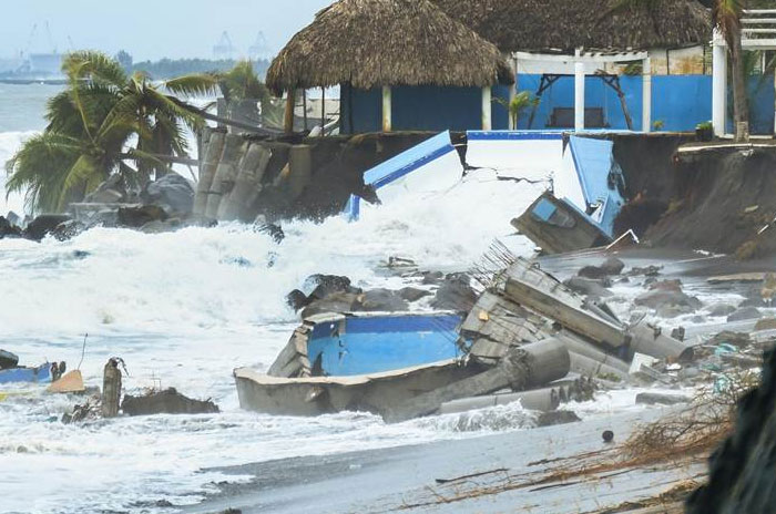
Cristina smashes Guatemala as global warming takes its toll
Tropical Storm Cristina is the latest in a series of global warming driven event that are pounding away at the viability of Guatemala’s Pacific coast. Rapidly rising seas, violent surf and increasingly powerful storms are clawing away coastal towns and neighborhoods, threatening economically critical tourism as infrastructure collapses.

Once in 200 year floods, tornadoes in Manitoba
A “once in two hundred years” flood hit western and southern Manitoba in mid-June, threatening the planting season and submerging a number of communities. More than 10 inches or rain and several tornadoes were sighted. Evacuations, power outages and washed out roads have been reported by authorities in the region.

Shocking heat up to 104°F across Kazakhstan, Mongolia worse
“Kazhydromet issued storm warnings for June 16 in 16 regions and in the cities of Astana and Almaty, with severe thunderstorms and extreme heat expected across the country, Qazinform News Agency reports. To the east, Mongolia is reporting 114°F.
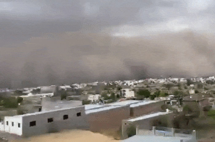
Massive Dust Storm Hits NW India with Zero Visibility
A massive dust storm swept across a highway in Rajasthan’s Churu district on Monday, reducing visibility to near zero and severely disrupting traffic movement as thick clouds of dust and strong winds engulfed the area.
Flash floods hit Texas Hill Country, one dead
Record torrential rains triggered flash flood warnings across San Antonio, Waco and surrounding counties. San Antonio fire crews responded to nine high-water rescue calls as floodwaters created hazardous driving conditions across the city..
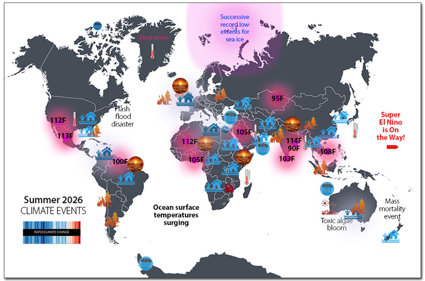
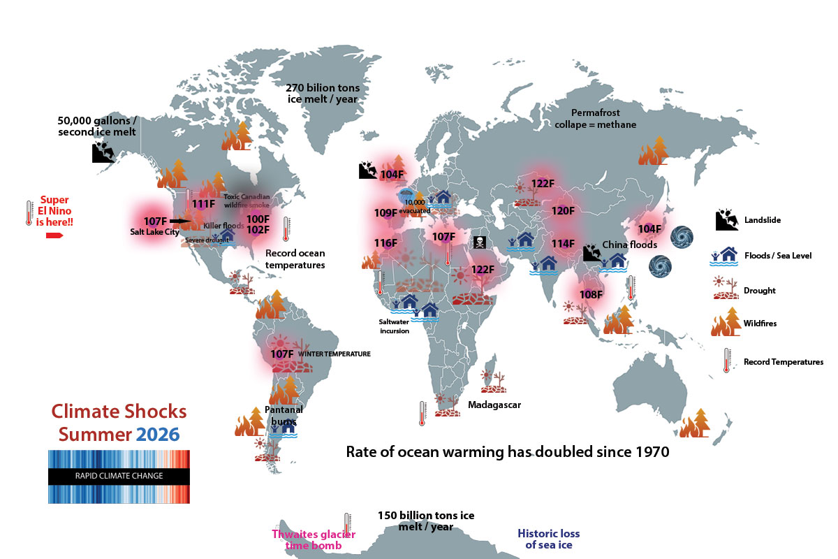
Drought | Flood | Heat
The European Centre for Medium-Range Weather Forecasts suggests this Super El Nino will be the strongest ever measured
New England is experiencing a serious heat wave already, with high temps topping 95°F in Boston even before summer is official. The intense heatwaves in Western Europe continue, especially in the UK. The global system that monitors of sea level rise in real time is being cut by the Trump administration: this is the three monkeys approach to denial. 2025 wildfires were the costliest ever globally. ANTARCTICA west coast missing an area of sea ice the size of France as crazy heat persists way down under. Driven by warming seas, red algae is invading the coast of Brittany.
Driven by warming oceans, red algae on Brittany coast comes “way early.”
Large quantities of red algae have washed up on beaches in Brittany far earlier than usual this year, a phenomenon local officials say is linked to rising temperatures and warmer spring weather. While they traditionally take place around the height of summer – often as late as October – these “blooms” (as they are called) increasingly appear in May and June as spring temperatures rise sooner on the heating planet.
Like green algae, red algae present a health risk when large accumulations begin to decompose during periods of hot weather. Some harmful algal blooms produce toxins that cause stomach pain, skin irritation, headaches and respiratory problems. They also release Hydrogen Sulfide (H2S) gas, a poison and sometimes lethal gas. Jogger Death By Algae: The 2026 event occurs ten years after a jogger died on the Breton coast from inhaling the gas.
In addition to the warming waters that accelerate algae growth, pollution from large scale pig farms in Brittany contribute to the problem
Globally, algae and toxic seaweed incursions are fouling coastlines around the planet, including Florida, Australia, the Pacific Islands and the extended western coast of Europe. READ MORE
.

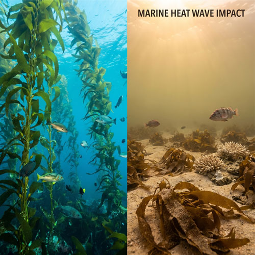
Climate impact on kelp forests seriously under estimated
Even if you aren’t exactly sure what a kelp forest is, the reality for these spectacular undersea ecosystems is dire. New research from the University of Victoria has found that the kelp forests around Vancouver Island were disappearing far earlier than scientists previously thought, highlighting that climate change has been altering these undersea ecosystems long before most people were aware anything was wrong.
SERIOUS CONSEQUENCES: Kelp forests are often called the “rainforests of the sea.” providing habitat for thousands of marine species, supporting fisheries, absorbing carbon, and reducing coastal erosion. Estimates suggest that 40–60% of kelp forests have been degraded or lost over the past 50 years, due to ocean warming and marine heatwaves, increasingly violent weather and pollution/ nutrient runoff.
Florida Orange juice is not just for breakfast anymore . . . or anything else
The Anita Bryant homophobic episodes of the 70’s is nothing compared to the existential crisis facing the collapsing Florida orange industry. The decline of Florida orange juice is one of the most dramatic agricultural crashes in modern history. Florida was once the world’s leading producer of orange juice, but production has fallen by roughly 90–95% since its peak in the late 1990s and early 2000s. The cause is a perfect storm of disease, violent weather and developers, with an underpinning of global warming exacerbating the catastrophe.

Weather chaos in Switzerland
A violent storm hit southern Ticino. Switzerland in early June as hailstones up to 3 inches in diameter damaged roofs, cars and fields. The storm set a new precipitation record for the southern slope of the Alps Within a few minutes, southern Ticino was transformed into a white landscape on Tuesday evening. A particularly heavy thunderstorm cell moved over the Mendrisiotto at around 9.30 pm, bringing torrential rain, strong gusts of wind and unusually large hailstones.
The Super El Niño: What to expect
El Niño has officially begun, and it is forecast to intensify into a very strong or “Super” El Niño with major shifts in global weather patterns and an even hotter climate, according to a new report released Thursday morning by the National Oceanic and Atmospheric Administration (NOAA).
New predictions from the European Centre for Medium-Range Weather Forecasts (ECMWF) indicate sea surface temperatures in the central equatorial Pacific Ocean will climb 5.47.2° F (3 C) above average by December 2026. The scariest predict a spike above 7.2° F (4 C).
El Niño is a periodic weather pattern in the tropical Pacific Ocean that alters winds and features unusually hot waters in the central and eastern Pacific. These changes in winds and ocean temperatures have knock-on effects on weather patterns worldwide.
NOAA’s Climate Prediction Center is giving this El Niño a 63% chance of becoming a “very strong” event (a Super El Niño) and one of the “largest El Niño events in the historical record. The Center is giving 100% odds of El Niño continuing through the fall and extremely high odds continuing into the winter.
WHAT WILL HAPPEN: Super El Niños transfer large amounts of heat from the ocean to the atmosphere, which is highly likely to mean another record setting year will follow in terms of global heat.
Effects to expect: Increase in heat waves | increased wildfire risk | greater stress on agriculture | extreme rainfall and flooding | increased drought especially in Australia, Indonesia, South Africa and rainforests | marine ecosystem disruption and extensive coral bleaching.

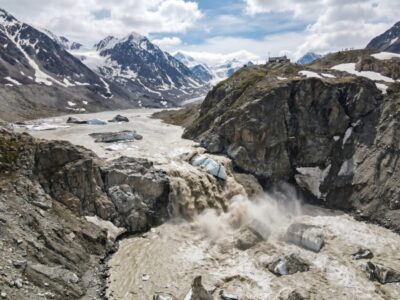
BC’s repeating Glacial Lake Outbursts reflect a growing global threat
For the third year in a row, evacuations have begun near the Place Glacier in Pemberton, British Colombia due to an imminent threat of a glacial lake outburst flood. Monitoring equipment shows that a lake near Place Glacier that saw outbursts in 2024 and 2025 is at risk of causing flooding again. The depth of the lake has reached the same level that it did when a previous outburst happened in 2025 — 80 ft. Scientists expect that the annual outbursts will occur until the glacier has completely receded.
GLOF events are increasing rapidly in Alpine regions around the world, threatening downstream villages and infrastructure. More on GLOF’s here.
Mumbai: When water crisis meets greed
Imagine a city of 20,000,000 that must depend on a massive fleet of private tankers trucks to supply water for the population. The tanker companies extract ground water from rapidly dwindling aquifers, often illegally. There are 500 water tanker owners and 2100 water tankers that operate in Mumbai.
Mumbai – the largest city in India – is facing a new escalation of its ongoing water supply crisis. While the Mumbai Water Tanker Association has backed off it’s strike after two days, the situation remains untenable in the extreme. The tanker companies were protesting the implementation of regulations that cut their legal rights to extract groundwater by about 10%. Those regulations were put in place because lakes and reservoirs are no longer able to meet demand. To make the situation worse, the amount of water extracted illegally from the rapidly dwindling aquifers is unknown.
The global water crisis is manifesting in more locations around the planet, with very little attention from national media. Current emergencies many decades in the making are the Ogallala Aquifer, the entire southwest, and a looming disaster in Corpus Christi (named for the body of our deceased lord and savior – fun stuff).
